- Mahendragarh district
-
Mahendragarh district
महेन्द्रगढ जिला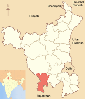
Location of Mahendragarh district in HaryanaState Haryana,  India
IndiaHeadquarters Narnaul Area 1,859 km2 (718 sq mi) Population 812,022 (2001) Population density 428 /km2 (1,110 /sq mi) Urban population 13.49% Literacy 69.89% Tehsils 1. Narnaul, 2. Mahendragarh Lok Sabha Constituencies Bhiwani-Mahendragarh (shared with Bhiwani district) Assembly Seats 4 Official website Mahendragarh district (Hindi: महेन्द्रगढ जिला) is one of the 21 districts of Haryana state in northern India. The district occupies an area of 1,859 km². The district has a population of 812,022 (2001 census). Narnaul town is the administrative headquarters of the district. Mahendragarh is one of the very few districts in India where the name of the district and its main town are different.
As of 2011 it is the third least populous district of Haryana (out of 21), after Panchkula and Rewari.[1]
Contents
Origin of name
The district is named after Mahendragarh town, which was previously known as Kanaud. The previous name was derived from the Kanaudia group of Brahmans. It was founded by Malik Mahdud Khan, a servant of Babur. There is a fort at Mahendragarh which was built by Maratha ruler, Tantia Tope during the 19th century. This fort was named as Mahendragarh in 1861 by Narendra Singh, the ruler of Patiala, in honour of his son, Mahendra Singh and consequently the town came to be known as Mahendragarh. The name of Narnaul Nizamat was changed to "Mahendragarh Nizamat".
History
Mahendragarh district was formed in 1948 by grouping different tracts of erstwhile princely states; Narnaul and Mahendragarh tehsils from Patiala State, Dadri (Charkhi Dadri) from Jind State and a part of Bawal nizamat from Nabha State. It became a part of Patiala and East Punjab States Union (PEPSU) state. On November 1, 1956, with the merger of PEPSU with Punjab, it became a part of Punjab state and with the formation of Haryana state in 1966, it became a part of the newly formed state. Rewari tehsil of Gurgaon district was added to it in 1972 but Rewari tehsil was made a separate district in 1989.
Geography
The district lies between north latitude 270 47 to 280 26 and east longitude 750 56’ to 760 51’. It is bounded on the north by Bhiwani and Rohtak districts, on the east by Rewari district and Alwar district of Rajasthan, on the south by Alwar, Jaipur and Sikar districts of Rajasthan, and on the west by Sikar and Jhunjhunu districts of Rajasthan.
Economy
In 2006 the Ministry of Panchayati Raj named Mahendragarh one of the country's 250 most backward districts (out of a total of 640).[2] It is one of the two districts in Haryana currently receiving funds from the Backward Regions Grant Fund Programme (BRGF).[2]
Divisions
Mahendragarh district is divided in to 2 tehsils, Narnaul and Mahendragarh and 3 sub-tehsils, namely, Nangal Chowdhary, Ateli Nangal and Kanina. Narnaul tehsil comprises 3 blocks: Narnaul, Nangal Chowdhary and Ateli Nangal. Mahendragarh tehsil divided in to 2 blocks: Mahendragarh and Kanina.
There are 4 Vidhan Sabha constituencies in this district: Ateli, Mahendragarh, Narnaul and Nangal Chaudhry. All of these are part of Bhiwani-Mahendragarh Lok Sabha constituency.[3]
Demographics
According to the 2011 census Mahendragarh district has a population of 921,680 ,[4] roughly equal to the nation of Fiji[5] or the US state of Delaware.[6] This gives it a ranking of 462nd in India (out of a total of 640).[4] The district has a population density of 485 inhabitants per square kilometre (1,260 /sq mi) .[4] Its population growth rate over the decade 2001-2011 was 13.43 %.[4] Mahendragarh has a sex ratio of 894 females for every 1000 males,[4] and a literacy rate of 78.9 %.[4]
References
- ^ "District Census 2011". Census2011.co.in. 2011. http://www.census2011.co.in/district.php. Retrieved 2011-09-30.
- ^ a b Ministry of Panchayati Raj (September 8, 2009). "A Note on the Backward Regions Grant Fund Programme". National Institute of Rural Development. http://www.nird.org.in/brgf/doc/brgf_BackgroundNote.pdf. Retrieved September 27, 2011.
- ^ "Delimitation of Parliamentary and Assembly Constituencies Order, 2008". The Election Commission of India. p. 157. http://eci.nic.in/eci_main/CurrentElections/CONSOLIDATED_ORDER%20_ECI%20.pdf.
- ^ a b c d e f "District Census 2011". Census2011.co.in. 2011. http://www.census2011.co.in/district.php. Retrieved 2011-09-30.
- ^ US Directorate of Intelligence. "Country Comparison:Population". https://www.cia.gov/library/publications/the-world-factbook/rankorder/2119rank.html. Retrieved 2011-10-01. "Fiji 883,125 July 2011 est."
- ^ "2010 Resident Population Data". U. S. Census Bureau. http://2010.census.gov/2010census/data/apportionment-pop-text.php. Retrieved 2011-09-30. "Delaware 897,934"
Dhana
External links

Bhiwani district Rewari district Jhunjhunun district, Rajasthan 
 Mahendragarh district

Sikar district, Rajasthan Jaipur district, Rajasthan Alwar district, Rajasthan  State of HaryanaCapital: Chandigarh
Topics Districts Tourist attractions Notable personalities Chief Ministers - Om Prakash Chautala
- Banarsi Das Gupta
- Bhupinder Singh Hooda
- Bansi Lal
- Bhajan Lal
- Devi Lal
- Birender Singh
- Hukam Singh
Categories:- 1948 establishments in India
- Districts of Haryana
- Mahendragarh district
- Haryana geography stubs

Wikimedia Foundation. 2010.