- South Wales
-
South Wales (Welsh: De Cymru) is an area of Wales bordered by England and the Bristol Channel to the east and south, and Mid Wales and West Wales to the north and west. The most densely populated region in the south-west of the United Kingdom, it is home to around 2.1 million people[1] and includes the capital city of Cardiff (population approximately 324,800), as well as Swansea and Newport. The Brecon Beacons national park covers about a third of South Wales, containing Pen y Fan, the highest mountain south of Snowdonia.
The extent of South Wales is loosely defined, but it is generally considered to be the area surrounding the M4 motorway, including the historic counties of Glamorganshire and Monmouthshire and sometimes extending westwards to include south Carmarthenshire and south Pembrokeshire. In the western extent, from Swansea westwards, local people would probably recognise that they lived in both South Wales and in West Wales - there is considerable overlap in these somewhat artificial boundaries. The northern border is particularly ill-defined, but the A40 may be a good approximation whilst others consider the more southerly Heads of the Valleys Road as the boundary.
Contents
History
The South Wales Valleys and upland mountain ridges were once a very rural area of great natural beauty, noted for its river valleys and ancient forests and lauded by romantic poets such as William Wordsworth as well as poets in the Welsh language, although the interests of the latter lay more in society and culture than in the evocation of natural scenery. This natural beauty changed to a considerable extent during the early Industrial Revolution when the Glamorgan and Monmouthshire valley areas were exploited for coal and iron. By the 1830s, hundreds of tons of coal were being transported by barge to ports in Cardiff and Newport. In the 1870s, coal was transported by railway networks to Newport Docks, at the time the largest coal exporting docks in the world, and by the 1880s coal was being exported from Barry in the Vale of Glamorgan.
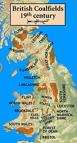
The Marquess of Bute, who owned much of the land north of Cardiff, built a steam railway system on his land that stretched from Cardiff into many of the South Wales Valleys where the coal was being found. Lord Bute then charged taxes per ton of coal that was transported out using his railways. With coal mining and iron smelting being the main trades of South Wales, many thousands of immigrants from the English Midlands, Scotland, Ireland, Cornwall and even Italy came and set up homes and put down roots in the region. Very many came from other coal mining areas such as Somerset, the Forest of Dean in Gloucestershire and the tin mines of Cornwall such as Geevor Tin Mine, as a large but experienced and willing workforce was required. Whilst some of the migrants left, many settled and established in the South Wales valleys between Swansea and Abergavenny, English speaking communities with a unique identity. Industrial workers were housed in cottages and terraced houses close to the mines and foundries in which they worked. The large influx over the years caused overcrowding which led to outbreaks of Cholera, and on the social and cultural side, the near-loss of the Welsh language in the area.
The 1930s inter-war Great Depression in the United Kingdom saw the loss of almost half of the coal pits in the South Wales coalfield and this number declined further in the years following World War II. This number is now very low, following the UK miners' strike (1984-1985), and the last 'traditional' deep-shaft mine, Tower Colliery, closed in January 2008.
Despite the intense industrialisation of the coal mining valleys, many parts of the landscape of South Wales such as the upper Neath valley, the Vale of Glamorgan and the valleys of the River Usk and River Wye remain distinctly beautiful and unspoilt and have been designated SSSI, Sites of Special Scientific Interest. In addition to this, many once heavily industrialised sites have reverted to wilderness, some provided with a series of cycle tracks and other outdoor amenities. Large areas of forestry and open moorland also contribute to the amenity of the landscape.

Famous industrialised areas in the nineteenth and twentieth centuries
Merthyr Tydfil (Welsh: Merthyr Tudful) grew around the Dowlais Ironworks which was founded to exploit the locally abundant seams of iron ore, and in time it became the largest iron producing town in the world. New coal mines were sunk nearby to feed the furnaces and in time produced coal for export. By the 1831 census, the population of Merthyr was 60,000 - more at that time than Cardiff, Swansea and Newport combined and its industries included coal mines, iron works, cable factory, engine sheds and sidings and many others. The town was also the birthplace of Joseph Parry, composer of the haunting hymn tune Myfanwy.
The Heads of the Valleys towns, including Rhymney, Tredegar and Ebbw Vale rose out of the industrial revolution; producing coal, metal ores and later steel.
Aberfan: The Merthyr Vale colliery began to produce coal in 1875. Spoil from the mine workings was piled on the hills close to the village which grew nearby. Tipping went on until the 1960s. The industry was by then nationalised but even the National Coal Board failed to appreciate the true nature of the danger they helped to create. In October 1966, heavy rain made the giant coal tip unstable. The recent dumping of small particles of coal and ash known as 'tailings' seems to have been partly responsible. A 30-foot-high (9.1 m) black wave tore downhill across the Glamorganshire Canal and swept away houses on its path towards the village school. 114 children and 28 adults were killed.
The Rhondda Valleys (Rhondda Fach and Rhondda Fawr) housed around 3,000 people in 1860 but by 1910 the population had soared to 160,000. The Rhondda had become the heart of a massive South Walian coal industry. Mining accidents below ground were common and in 1896 fifty-seven men and boys were killed in a gas explosion at the Tylorstown Colliery. An enquiry found that the pit involved had not been properly inspected over the previous fifteen months.
Ebbw Vale - the valley of the Ebbw River which stretches from the town of Ebbw Vale to Newport includes the mining towns and villages of Newbridge, Risca, Crumlin, Abercarn and Cwmcarn. The Carboniferous Black Vein coal seams in the area lay 900 feet below the surface and the mining activity associated with it was responsible for many tragic subsurface explosions, roof collapses and mining accidents.
Now the Valleys' heavy industrial past is overprinted with urban regeneration, tourism and multi-national investment. Large, empty factory units, or ones turned over to retail use, witness to the lack of success in replacing older industries.
Gallery
-

The countryside of the Vale of Glamorgan
-

Section of the south-eastern Cardiff skyline.
-

Western Central Cardiff from the Cardiff Eye (60m Wales Wheel), Cardiff
-

The Big Pit National Coal Museum at Blaenavon - exhibiting South Wales' economic past in coal mining
-

The view from Ebbw Vale in the South Wales Valleys.
-

South Wales Coastline overlooking the Bristol Channel at Llantwit Major
Language
The language of the vast majority of people in South Wales is English, but there are also many who speak Welsh. In western parts of Glamorgan, particularly the Neath and Swansea Valleys, there remain significant Welsh-speaking communities such as (Ystradgynlais and Ystalyfera) which share a heritage with the fellow ex-Anthracite mining areas of eastern Carmarthenshire, as much as the Glamorgan valleys.
The local slang dialect and phrases of the South Wales Valleys communities have been referred to as 'Wenglish', with often comic effect [4]. The dialect is found also in such coastal towns as Barry, as featured in the BBC hit comedy series Gavin and Stacey. Compared with such regional English dialects as those of Yorkshire, the local speech seems to be very little studied or appreciated.
Welsh, however, is now a compulsory language up to GCSE level for all students who start their education in Wales. This has meant the strength of the language, as a 2nd language, has increased considerably in the last 20 years. Several schools offering Welsh-language education operate in this area, for example Ysgol Gyfun Llanhari in Pontyclun, Ysgol Gyfun Y Cymmer in Porth the Rhondda, Ysgol Gyfun Rhydywaun in Penywaun in the Cynon Valley, Ysgol Gyfun Gwynllyw in Pontypool, Ysgol Gyfun Cwm Rhymni in Blackwood, Ysgol Gymraeg Plasmawr in Cardiff & Ysgol Gyfun Garth Olwg in Church Village, Ysgol Gyfun Maes Yr Yrfa in Carmarthenshire which have all done much to enhance the status of the language among young people.
A significant number of people from ethnic-minority communities speak another language as their first language, particularly in Cardiff and Newport. Commonly spoken languages in some areas include Punjabi, Bengali, Arabic, Somali and Chinese, and increasingly Eastern European languages such as Polish.
Culture
See also: Culture of WalesThe traditional pastimes of the area include rugby and music. Today music ranges from the traditional Welsh Male Voice choirs of the Valleys such as Treorchy Male Choir to the South Wales hardcore scene which plays a dominant role in the Cardiff music scene. Bands such as Lostprophets, Bullet for My Valentine, Feeder, Stereophonics, Manic Street Preachers, Funeral for a Friend, The Automatic, Skindred, Foreign Legion, Kids In Glass Houses and The Blackout all come from the South Wales area. In the nineteenth and earlier twentieth centuries there was a vigorous literary and musical culture centred round eisteddfodau held in the area [2][3][4]. Despite a few timid attempts to emulate this literature in English, it can be argued that few writers seem to connect either with the landscape or the literary tradition [5] The one exception, to some extent, can be considered to be Dylan Thomas [6].
Religion
The South Wales landscape is marked by numerous chapels, places of worship (past and present) of the various Christian Nonconformist congregations. The Baptist congregation at Ilston, Gower, felt compelled to move to Swansea, Massachusetts [7], but after the restoration of Anglican worship in 1662 several "gathered" churches survived belonging to the Baptist, Independent and Presbyterian denominations. In the 18th century members of some of these congregations became dissatisfied with the theological innovations of some trained ministers, and created new congregations such as Hengoed near Ystrad Mynach [8] In the same century, churches were sometimes involved in the Methodist movement, especially Groeswen and Watford near Caerphilly, which both received frequent visits from John Wesley [9][10] The largest denomination, however, became the Calvinist Methodists (later the Presbyterian Church of Wales), whose distinctive grey stone chapels can be seen in many parts. These were mainly Welsh language congregations. Anglicanism in South Wales became autonomous from the Church of England with the Welsh Disestablishment Act in 1920, but the immediate demise of the denomination feared at that time has not taken place [11][12]. The Roman Catholic community, despite systematic persecution, survived in the 17th to 19th centuries, especially in Brecon and among minor gentry such as the Vaughans of Welsh Bicknor, on the Monmouthshire - Herefordshire border [13][14]. Among members of worldwide origin in later urban Catholic congregations were the Bracchis, Italians in the café and catering trades often from Bardi in the Apennines [15] Post-war diversity has brought such developments as interesting buildings used as mosques, especially in Cardiff and Newport, Sikh gurdwaras, including one on the mountain near Abercynon [16] and a growing number of Evangelical and Pentecostal congregations. These often add a strongly international element into local life, such as the "Pont" twinning project between Pontypridd and Mbale, Uganda, and the creation of "Fairtrade" relationships with primary producers worldwide [17].
Industry today
The former heavy industries of coal and iron production have disappeared since the economic struggles of the 1970s, with the closures of that decade continuing sharply into the 1980s, and by July 1985 just 31 coal pits remained in the region.[18]Further closures left the region with just one deep mine by the early 1990s,[19]and this finally closed in January 2008, by which time it had transferred to private ownership after being sold off by the National Coal Board.[20]
These industries have since largely replaced by service sector industries.
The cities along the M4 corridor are home to a number of high-profile blue-chip companies such as Admiral Insurance, Legal & General and the Welsh based Principality Building Society. A large number of telephone call centres are located in the region and in particular in the Valleys area. Merthyr Tydfil is home to the principal UK call centre for German mobile telephone company, T-Mobile. Many jobs are also provided in small-scale and family businesses [21]. It is clear from anecdotal personal contacts, apart from official figures, that the new industries have so far failed to cope with the task of providing stable employment for the large number of employable people resident in the area.
The television and film sectors are fast becoming a major industry in South Wales, with the development, by the BBC, of a vast dedicated production studio in Nantgarw, near Pontypridd, for the highly successful Doctor Who series. Lord Attenborough is shortly due to open the first completely new film studio in the UK in over fifty years. Dragon International Film Studios, a huge purpose-built studio complex located alongside the M4 motorway between Bridgend and Llantrisant, contains a number of large soundstages which have already attracted the interest of a number of Hollywood directors and producers alike, looking for suitable facilities in Europe.
Local media
Radio stations in the area include:
- Real Radio
- Red Dragon FM
- The Wave 96.4 FM
- Swansea Sound
- Bay Radio
- 97.1 Radio Carmarthenshire
- 102.5 Radio Pembrokeshire
- 97.5 Scarlet FM
- 106.3 Bridge FM
- Afan FM
- BBC Radio Wales
- BBC Radio Cymru
- Nation Radio
- Kiss 101
The Welsh national media is based in Cardiff, with the BBC, ITV and S4C all having their studios and offices in the capital.
Cardiff also has its own television station, Capital TV, based in the Link Trade Park in Penarth Road, Cardiff. The channel broadcasts to most of Cardiff on terrestrial frequency 49. The company runs alongside with local media studes centre, Media4Schools which produces small videos in co-operation with local schools (CardiffTV4School and ValeTV4Schools).
See also
- South East Wales
- West Wales
- Mid Wales
- North Wales
- Geography of Wales
- Subdivisions of Wales
- M4 Corridor
- South Wales coalfield
- South Wales Valleys
- New South Wales in Australia
References
- ^ http://www.bbc.co.uk/wales/culture/sites/aboutwales/pages/people.shtml
- ^ Scorpion, editor, Cofiant Caledfryn Bala 1877
- ^ Rhys, Beti, Dyfed: Bywyd a Gwaith Evan Rees 1850-1923 Gwasg Gee, Dinbych, 1984
- ^ Walters, Huw, Canu'r Pwll a'r Pulpud: Portread o'r Diwylliant Barddol Cymraeg yn Nyffryn Aman Cyhoeddiadau Barddas 1987
- ^ Rees-Davies, Ieuan, compiler, Caniadau Cwm Rhondda: Detholiad o Delynegion, Sonedau a Chaneuon Cymraeg a Saesneg Foyle's Welsh Depot, London 1928. The rust has gathered on the plough, The tide of Autumn here is high, The hills are at their reddest now... (Hills of the Rhondda in Autumn by Huw Menai.)
- ^ Davies, Aneurin Talfan, Crwydro Sir Gâr Llyfrau'r Dryw, Llandybie 1955. Pages 104ff
- ^ Vaughan-Thomas, Wynford Portrait of Gower Robert Hale, London 1976, 1983, pages 84-85
- ^ Jenkins, John Gwili, Hanfod Duw a Pherson Crist: Athrawiaeth y Drindod a Duwdod Crist, yn bennaf yn ei pherthynas â Chymru Gwasg y Brython, Liverpool 1931.
- ^ Evans, Beriah Gwynfe, Diwygwyr Cymru published by the author, Caernarfon 1900
- ^ John Wesley's Journal (Abridged Edition) London 1903
- ^ Llandaff Diocesan Yearbook, circa 1977
- ^ complete list of parishes and clergy in Crockford's Clerical Directory,e.g. 2000-2001, Church House Publishing, Great Smith Street, London SW1, 1999
- ^ Cusack O'Keefe, Madge Four Martyrs of South Wales and the Marches published by the Archdiocese of Cardiff 1970
- ^ A Mill Hill Father, Remembered in Blessing: The Courtfield Story Sands & Co. London 1955, 1969. Until the 1890s Courtfield and Welsh Bicknor parish were part of NMonmouthshire, and hence in South Wales
- ^ popular accounts; display at St Fagans Museum, Cardiff.
- ^ personal acquaintance
- ^ personal knowledge
- ^ [1]
- ^ [2]
- ^ [3]
- ^ Business analysis with the former INDIS, Mid Glamorgan industrial information unit
Categories:- Regions of Wales
- Subdivisions of Wales
-


Wikimedia Foundation. 2010.